The Tioughnioga (pronounced Ty-off-nee-o-ga) River is a 34.2-mile-long tributary of the Chenango River in central New York in the United States. It drains a dissected plateau area east of the Finger Lakes at the northernmost edge of the watershed of the Susquehanna River. The name comes from a native word for “forks of the river” or “meeting of waters”.
The Tioughnioga rises in two branches in upstate New York southeast of Syracuse, with the East Branch sometimes regarded as the main branch. The West Branch, 15.6 miles long, issues from Tully Lake, approximately 2 miles south of Tully on the Onondaga-Cortland county line, and flows south.
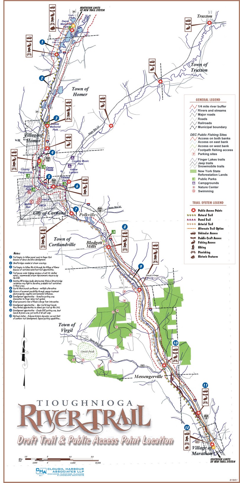
The east branch of the Tioughnioga River begins east of the Finger Lakes in Madison County, where it is called the Tioughnioga Creek. As the Tioughnioga Creek, it flows into Cortland County and the Finger Lakes, increasing in size with the addition of Labrador Creek at Truxton. Then, as the Tioughnioga River, it works its way southwest to the City of Cortland where it picks up the west branch and makes a slight turn to the southeast. When the river picks up the west branch in Cortland, it increases in size considerably and straightens out somewhat. The number of rocks in the river increases as does the river’s difficulty from a paddling point of view. There are fewer farms in this region because the valley narrows, especially around the Village of Marathon. It continues to flow southeast through Cortland County into Broome County where it meets the Chenango River at Chenango Forks.
Early in Cortland County the Tioughnioga River was used to transport products to market through the Susquehanna River system. Rafts, flat boats and vessels called “arks” carried salt, potash, pork, dried apples, maple sugar, whiskey and other commodities. This same mode of transportation was also employed throughout the Southern Tier. Rivers and streams throughout this region were navigated, particularly in early spring during high water. The head of navigation on the Tioughnioga was the village of Port Watson, which is now the far end of Port Watson Street in Cortland where the Route 11 bridge crosses the river. The river route south was Port Watson to Chenango Forks, the confluence of the Tioughnioga and Chenango Rivers, which emptied into the Susquehanna River at Binghamton, then west through Owego to what is now Sayre and Athens, Pa., and then south on the Susquehanna to Columbia, Wilkes Barre, Harrisburg and Baltimore.
In those days the area was heavily timbered so there was a greater volume of water in the river than there is today—especially at the time of year during “high water.” The river was declared by law a public highway in 1814. The importance of the Tioughnioga as a waterway lasted until about the time the Syracuse & Binghamton Railroad was opened in 1854.
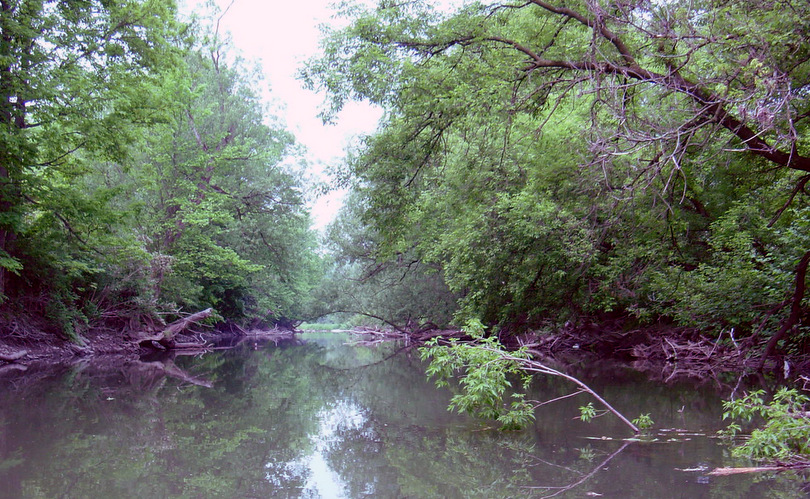
Skip, Bob, Steve and I paddled the Tioughnioga River from East Homer to Chenango Forks. The Tioughnioga River is a narrow river with several twist, turns and easy “swifts” to keep paddlers engaged. It does parallel many roadways and highways and you’re never out of earshot of civilization. Flooding in early spring left piles of tree debris at curves.
The water level gauge at Cortland (http://waterdata.usgs.gov/nwis/uv?01509000 ) was showing 3.1 feet with ~150 cubic feet per second discharge, well below the median 300 CFS for this time of year.The lower water level meant that we were able to easily run a couple of obstacles – a 2’ dam below the East Homer Bridge and a few strainers lower on the East Branch, but conversely we had to drag our loaded Royalex canoes through some shallow areas – probably 15 times over the two days.
Where East and West Branches meet the Tioughnioga River is born. Cortland appears below the confluence, above the right (western) bank of the Tioughnioga. From this point the river bends southward to form the eastern boundary of industrial Cortland and then assumes a southeasterly direction.
Just below Cortland we met up with two teenagers paddling from Cortland to Marathon with no knowledge of the distance/time it would take, no ten essentials, no water, only a cell phone and a Dad expecting to pick them up in Marathon. As the temperatures were in the 80s I gave them a bottle of water. We leapfrogged each other a couple of times and later saw a car driving slow,
Through out the trip we passed several hundreds of Canada geese; about half of which flew off upon our approach and the rest just watched us from close range.I also heard and saw an unusual number of Northern Orioles – a very pretty sounding bird.
Below Gridley Creek Junction and above Marathon the valley floor widens to 3/10 mile with steep slopes and islands, and side channels offering sites for overnight camping. We took advantage of an island for camping overnight. A wonderful site except for the truck noise on I-81 and an early morning south bound freight train less than 30 yards away across the river. The situation prompted a later article on guerrilla camping for paddlers. The early wake up call got Steve making coffee and we had a leisurely breakfast while serenaded by turkeys coming off their hillside roosts. We packed up and were paddling by 7:40am.
Given the forecast for a hot humid day I commented to Steve that I was glad for the early start and hoped that it would mean that we wouldn’t be paddling at 2 in the afternoon. We were close.We arrived at Chenango Forks at 2:10 with threatening rumbles of thunder.While we didn’t get hit with any serious rain I understand there were some violent thunderstorms in the southern tier during the afternoon.We were just lucky.
Overall the Tioughnioga River offers a nice paddle and certainly offers lots of options for day trips for those so inclined due to multiple access points. Access points to the river include:
- East Homer Crossing Road Bridge-Hamlet of East Homer. Just off State Route 13 on East Homer Crossing Road (County Road 108C). Park on the southeast side of the bridge. Enter from that side. No amenities.
- East River Crossing Road Bridge-Hamlet of East River. Just off State Route 13 south of East Homer. Park on the southeast corner of the bridge. Enter from the northwest or southwest corners. No amenities.
- Yaman Park-Cortland. The entrance to the park is on Kennedy Parkway on the east side of State Route 13 just north of the intersection of 13 with Interstate 81. Follow the parkway straight into the park, then curve to the right around the swimming and picnic areas to the back of the park. The river runs along here. There is a dedicated parking area with a concrete ramp and dock. The park has supervised swimming, a bathhouse, picnic pavilions, an enclosed skateboard park, a gazebo, a playground, and toilets. This is probably the most popular launch site along the river for many reasons.
- Blodgett Mills Road Bridge-Hamlet of Blodgett Mills (D). Just off U.S. Route 11. Park on the southwest side of the bridge, enter on the same side. Small parking lot. No amenities.
- State Route 392 Bridge-Hamlet of Messengerville (D). Just off U.S. Route 11. There are two parking options. 1) Park in the state-designated parking area on the southeast side of the bridge and enter from that side with a short portage or 2) enter from the northwest side, using a dirt drive that goes all the way to the riverbank. No amenities.
- U.S. Route 11-Marathon (D) This area is 1.2 mi./2 km. north of the intersection of routes 11 and 221 in Marathon. Large parking area. Short portage down a slope to the water. No amenities.
- Lovell Field-Village of Marathon. From the intersection of routes 11 and 221 in Marathon, drive one block south on Route 11 (Broome Street) and turn west onto Brink Street. Drive the short distance to the end of the street. The entrance to the park should be on your left. Drive straight into the park about 500 ft./152 m. The river and launch area will be on your right. Concrete ramp and dock. Large parking area. The park has ball fields, portable toilets, a playground, tennis courts, and picnic tables. This is the last launch site in the county.


